Bath, Pennsylvania - U.S.A.
Charles A. Giannetta
Chief Meteorologist - Professor
"N O T E"
All weather articles written by the author,
weather records for Bath, Pa. USA, graphs,
graphics, pictures, are copyrighted and are owned by the author.
If you make use of data from this site,
please make reference to the: Station Licensee: Virginia T. Giannetta.
Owner - Author: Charles A. Giannetta. Computer Consultant: Charles E. Giannetta
& This Web Site. Thank you.

What is this phenomenon called El-NIÑO
EL-NIÑO is Spanish meaning Christ Child. Every year around
Christmas time, this phenomenon occurs in the Pacific Ocean off the
shores of Peru and Ecuador, South America, and along the equator
westward to Australia and Indonesia. This phenomenon combines the
tropical atmosphere and tropical ocean waters of the Pacific Ocean.
At this time it is not certain which of the two dominate, and was
given the name EL-NIÑO by the Peruvian fishermen.
Normally high pressure is located in the eastern Pacific off the
shores of Ecuador and Peru, likewise, low pressure is situated over
the western Pacific in the area of Indonesia and Australia. This
produces winds that flow east to west, know as the Northeast Trade
Winds, from high to lower pressure.
The wind blowing from east to west, (high to low pressure)
causes the warm surface water to also move from east to west. As the
water moves towards Indonesia and Australia, colder waters, rich in
nutrients, rise from the depths of the ocean to replace the warmer
surface water, this is know as (UPWELLING). UPWELLING occurs along
narrow corridors which run east to west along the equator, and off
the coast of Ecuador and Peru, and are 100 to 200 miles wide.
The water rising from the depths of the ocean, some 500 to over
3,000 feet below the surface is rich in nutrients, and replaces the warmer
surface waters which are moving westward. The abundance of these rich
nutrients enhances the growth of (Phytoplankton), which in turn support a
high amount of fishery. When these conditions prevail, fish are abundant in
these waters and fishing is at its best, producing some of the worlds
largest fish catches for the Peruvian Fisherman. At one time, the Peruvian
anchovy fishing was one of the largest in the world. Before over fishing,
the annual anchovy catch at time topped over 10 million tons.
The EL-NIÑO phenomenon occurs every year around Christmas time, and
generally last from 2 to 3 months, this is considered to be an average
or weak EL-NIÑO. Every so many years a strong EL-NIÑO will start earlier
in the fall and last well into late spring or early summer in the Northern
Hemisphere, late fall and early winter in the Southern Hemisphere.
During the fall in the Northern Hemisphere, the winds which are blowing
from east to west, (NORTHEAST TRADE WINDS), from the equator to about 30
degrees north latitude, in the Southern Hemisphere, the (SOUTHEAST TRADE
WINDS), from the equator to about 30 degrees south latitude, become weak
and by Christmas time are reversed, these winds and now blowing west to east,
from the area of Australia and Indonesia towards South America, or
from high pressure over the western tropical Pacific towards lower pressure
over the eastern tropical Pacific.
The winds blowing from west to east move the warm waters eastward, when
this occurs, The UPWELLING of the colder water rich in nutrients from
the depths of the Pacific Ocean weakens, or does not occur at all. This
lack of UPWELLING of colder water rich in nutrients causes a lack of food
for the fish and sea life in the area, thus the fish, seabirds and other
animal and wildlife which the phytoplankton and fish help support in the
food chain, migrate away from the area. Some sea life normally found in
these tropical waters migrate as far north to off the western coast of the
United States.
As the warm water moves eastward, it strikes the western coast of
South America, and then spreads out, when this happens, the sea level in the
eastern Pacific along the coasts of Ecuador and Peru rise about 1 foot,
likewise, the sea levels in the western Pacific lower by about a foot,
exposing and destroying any exposed coral reefs of the many islands in the
Pacific. These warm waters spread south along the shores of South America
and northward to off the western coast of the United States, and as far
north as Canada. Ocean water temperature at the surface rise over 10
degrees from normal levels of 70 Degs. F. to well into the 80s.
In the future look for weather articles on: Hurricanes. Tornadoes.
Floods. Thunderstorms. Winds. Radar. Atmosphere. Orographic Lifting.
Adiabatic Process. Clouds. Relative Humidity. Water. Temperature and
Temperature Scales, and many more.
The phenomenon of EL-Niño has been going on for millions of years.
Since it occurs around Christmas time, it was given the name Christ Child
by the Peruvian fishermen some 4 centuries ago. It is only in the past 10
to 20 years that we have become alert to what its world wide effects are.
Through research it has been learned that an El-Niño occurs about every 3
to 7 years and no two events are alike.
The last major El-Niño occurred in 1982-1983. At that time it was still not
understood about its world wide effects. So as not to be caught off guard
again, the documentation and analysis of past and present weather,
and weather related events are being conducted.
Currently observations are carried on by ships, weather satellites,
space shuttle, land and sea based stations in the Pacific as well as
thousands of weather stations through-out the world.
Many buoys containing weather instruments and other electronic devices
have been deployed in the Pacific from Mexico to South America and along
the equator to Indonesia and Australia. These observe and record information
about the atmosphere and ocean water. The information is relayed via
satellite to weather centers around the world for analysis.
The Effects of El-Niño are strongest during the winter in the Northern
Hemisphere, summer in the Southern Hemisphere. Winters are milder
over portions of Western Canada, and the northern portions of the United
States. Heavy rains and severe weather occur more frequently over the
southern United States.
The northern polar jet stream associated with the polar front is a steering
mechanism in the atmosphere. It forms a boundary between the cold dry air
to the north and warm moist air to the south and is usually located over
the central and southern United States during the winter months. During an
El-Niño, the polar jet stream becomes situated further north along the
U.S./Canadian border, in a somewhat west to east position. This position
creates a blocking action of the cold air masses which are moving south from
the interior of Canada and the Arctic regions, allowing warm moist air from
the tropics to penetrate farther north than usual.
Another jet steam which is called the southern jet stream is usually located
at 15-20 degrees north latitude. During El-Niño this jet shifts north over
the southern United States to 30-35 degrees north latitude.
Charles A. Giannetta |
|---|
Chief Meteorologist - Professor
"N O T E"
All weather articles written by the author,
weather records for Bath, Pa. USA, graphs,
graphics, pictures, are copyrighted and are owned by the author.
If you make use of data from this site,
please make reference to the: Station Licensee: Virginia T. Giannetta.
Owner - Author: Charles A. Giannetta. Computer Consultant: Charles E. Giannetta
& This Web Site. Thank you.
What is this phenomenon called El-NIÑO
EL-NIÑO is Spanish meaning Christ Child. Every year around
Christmas time, this phenomenon occurs in the Pacific Ocean off the
shores of Peru and Ecuador, South America, and along the equator
westward to Australia and Indonesia. This phenomenon combines the
tropical atmosphere and tropical ocean waters of the Pacific Ocean.
At this time it is not certain which of the two dominate, and was
given the name EL-NIÑO by the Peruvian fishermen.
Normally high pressure is located in the eastern Pacific off the
shores of Ecuador and Peru, likewise, low pressure is situated over
the western Pacific in the area of Indonesia and Australia. This
produces winds that flow east to west, know as the Northeast Trade
Winds, from high to lower pressure.
The wind blowing from east to west, (high to low pressure)
causes the warm surface water to also move from east to west. As the
water moves towards Indonesia and Australia, colder waters, rich in
nutrients, rise from the depths of the ocean to replace the warmer
surface water, this is know as (UPWELLING). UPWELLING occurs along
narrow corridors which run east to west along the equator, and off
the coast of Ecuador and Peru, and are 100 to 200 miles wide.
The water rising from the depths of the ocean, some 500 to over
3,000 feet below the surface is rich in nutrients, and replaces the warmer
surface waters which are moving westward. The abundance of these rich
nutrients enhances the growth of (Phytoplankton), which in turn support a
high amount of fishery. When these conditions prevail, fish are abundant in
these waters and fishing is at its best, producing some of the worlds
largest fish catches for the Peruvian Fisherman. At one time, the Peruvian
anchovy fishing was one of the largest in the world. Before over fishing,
the annual anchovy catch at time topped over 10 million tons.
The EL-NIÑO phenomenon occurs every year around Christmas time, and
generally last from 2 to 3 months, this is considered to be an average
or weak EL-NIÑO. Every so many years a strong EL-NIÑO will start earlier
in the fall and last well into late spring or early summer in the Northern
Hemisphere, late fall and early winter in the Southern Hemisphere.
During the fall in the Northern Hemisphere, the winds which are blowing
from east to west, (NORTHEAST TRADE WINDS), from the equator to about 30
degrees north latitude, in the Southern Hemisphere, the (SOUTHEAST TRADE
WINDS), from the equator to about 30 degrees south latitude, become weak
and by Christmas time are reversed, these winds and now blowing west to east,
from the area of Australia and Indonesia towards South America, or
from high pressure over the western tropical Pacific towards lower pressure
over the eastern tropical Pacific.
The winds blowing from west to east move the warm waters eastward, when
this occurs, The UPWELLING of the colder water rich in nutrients from
the depths of the Pacific Ocean weakens, or does not occur at all. This
lack of UPWELLING of colder water rich in nutrients causes a lack of food
for the fish and sea life in the area, thus the fish, seabirds and other
animal and wildlife which the phytoplankton and fish help support in the
food chain, migrate away from the area. Some sea life normally found in
these tropical waters migrate as far north to off the western coast of the
United States.
As the warm water moves eastward, it strikes the western coast of
South America, and then spreads out, when this happens, the sea level in the
eastern Pacific along the coasts of Ecuador and Peru rise about 1 foot,
likewise, the sea levels in the western Pacific lower by about a foot,
exposing and destroying any exposed coral reefs of the many islands in the
Pacific. These warm waters spread south along the shores of South America
and northward to off the western coast of the United States, and as far
north as Canada. Ocean water temperature at the surface rise over 10
degrees from normal levels of 70 Degs. F. to well into the 80s.
In the future look for weather articles on: Hurricanes. Tornadoes.
Floods. Thunderstorms. Winds. Radar. Atmosphere. Orographic Lifting.
Adiabatic Process. Clouds. Relative Humidity. Water. Temperature and
Temperature Scales, and many more.
The phenomenon of EL-Niño has been going on for millions of years.
Since it occurs around Christmas time, it was given the name Christ Child
by the Peruvian fishermen some 4 centuries ago. It is only in the past 10
to 20 years that we have become alert to what its world wide effects are.
Through research it has been learned that an El-Niño occurs about every 3
to 7 years and no two events are alike.
The last major El-Niño occurred in 1982-1983. At that time it was still not
understood about its world wide effects. So as not to be caught off guard
again, the documentation and analysis of past and present weather,
and weather related events are being conducted.
Currently observations are carried on by ships, weather satellites,
space shuttle, land and sea based stations in the Pacific as well as
thousands of weather stations through-out the world.
Many buoys containing weather instruments and other electronic devices
have been deployed in the Pacific from Mexico to South America and along
the equator to Indonesia and Australia. These observe and record information
about the atmosphere and ocean water. The information is relayed via
satellite to weather centers around the world for analysis.
The Effects of El-Niño are strongest during the winter in the Northern
Hemisphere, summer in the Southern Hemisphere. Winters are milder
over portions of Western Canada, and the northern portions of the United
States. Heavy rains and severe weather occur more frequently over the
southern United States.
The northern polar jet stream associated with the polar front is a steering
mechanism in the atmosphere. It forms a boundary between the cold dry air
to the north and warm moist air to the south and is usually located over
the central and southern United States during the winter months. During an
El-Niño, the polar jet stream becomes situated further north along the
U.S./Canadian border, in a somewhat west to east position. This position
creates a blocking action of the cold air masses which are moving south from
the interior of Canada and the Arctic regions, allowing warm moist air from
the tropics to penetrate farther north than usual.
Another jet steam which is called the southern jet stream is usually located
at 15-20 degrees north latitude. During El-Niño this jet shifts north over
the southern United States to 30-35 degrees north latitude.
"N O T E"
All weather articles written by the author,
weather records for Bath, Pa. USA, graphs,
graphics, pictures, are copyrighted and are owned by the author.
|
|---|
What is this phenomenon called El-NIÑO
EL-NIÑO is Spanish meaning Christ Child. Every year around
Christmas time, this phenomenon occurs in the Pacific Ocean off the
shores of Peru and Ecuador, South America, and along the equator
westward to Australia and Indonesia. This phenomenon combines the
tropical atmosphere and tropical ocean waters of the Pacific Ocean.
At this time it is not certain which of the two dominate, and was
given the name EL-NIÑO by the Peruvian fishermen.
Normally high pressure is located in the eastern Pacific off the
shores of Ecuador and Peru, likewise, low pressure is situated over
the western Pacific in the area of Indonesia and Australia. This
produces winds that flow east to west, know as the Northeast Trade
Winds, from high to lower pressure.
The wind blowing from east to west, (high to low pressure)
causes the warm surface water to also move from east to west. As the
water moves towards Indonesia and Australia, colder waters, rich in
nutrients, rise from the depths of the ocean to replace the warmer
surface water, this is know as (UPWELLING). UPWELLING occurs along
narrow corridors which run east to west along the equator, and off
the coast of Ecuador and Peru, and are 100 to 200 miles wide.
The water rising from the depths of the ocean, some 500 to over
3,000 feet below the surface is rich in nutrients, and replaces the warmer
surface waters which are moving westward. The abundance of these rich
nutrients enhances the growth of (Phytoplankton), which in turn support a
high amount of fishery. When these conditions prevail, fish are abundant in
these waters and fishing is at its best, producing some of the worlds
largest fish catches for the Peruvian Fisherman. At one time, the Peruvian
anchovy fishing was one of the largest in the world. Before over fishing,
the annual anchovy catch at time topped over 10 million tons.
The EL-NIÑO phenomenon occurs every year around Christmas time, and
generally last from 2 to 3 months, this is considered to be an average
or weak EL-NIÑO. Every so many years a strong EL-NIÑO will start earlier
in the fall and last well into late spring or early summer in the Northern
Hemisphere, late fall and early winter in the Southern Hemisphere.
EL-NIÑO is Spanish meaning Christ Child. Every year around Christmas time, this phenomenon occurs in the Pacific Ocean off the shores of Peru and Ecuador, South America, and along the equator westward to Australia and Indonesia. This phenomenon combines the tropical atmosphere and tropical ocean waters of the Pacific Ocean. At this time it is not certain which of the two dominate, and was given the name EL-NIÑO by the Peruvian fishermen.
Normally high pressure is located in the eastern Pacific off the shores of Ecuador and Peru, likewise, low pressure is situated over the western Pacific in the area of Indonesia and Australia. This produces winds that flow east to west, know as the Northeast Trade Winds, from high to lower pressure.
The wind blowing from east to west, (high to low pressure) causes the warm surface water to also move from east to west. As the water moves towards Indonesia and Australia, colder waters, rich in nutrients, rise from the depths of the ocean to replace the warmer surface water, this is know as (UPWELLING). UPWELLING occurs along narrow corridors which run east to west along the equator, and off the coast of Ecuador and Peru, and are 100 to 200 miles wide.
The water rising from the depths of the ocean, some 500 to over 3,000 feet below the surface is rich in nutrients, and replaces the warmer surface waters which are moving westward. The abundance of these rich nutrients enhances the growth of (Phytoplankton), which in turn support a high amount of fishery. When these conditions prevail, fish are abundant in these waters and fishing is at its best, producing some of the worlds largest fish catches for the Peruvian Fisherman. At one time, the Peruvian anchovy fishing was one of the largest in the world. Before over fishing, the annual anchovy catch at time topped over 10 million tons.
The EL-NIÑO phenomenon occurs every year around Christmas time, and generally last from 2 to 3 months, this is considered to be an average or weak EL-NIÑO. Every so many years a strong EL-NIÑO will start earlier in the fall and last well into late spring or early summer in the Northern Hemisphere, late fall and early winter in the Southern Hemisphere.
During the fall in the Northern Hemisphere, the winds which are blowing from east to west, (NORTHEAST TRADE WINDS), from the equator to about 30 degrees north latitude, in the Southern Hemisphere, the (SOUTHEAST TRADE WINDS), from the equator to about 30 degrees south latitude, become weak and by Christmas time are reversed, these winds and now blowing west to east, from the area of Australia and Indonesia towards South America, or from high pressure over the western tropical Pacific towards lower pressure over the eastern tropical Pacific.
The winds blowing from west to east move the warm waters eastward, when this occurs, The UPWELLING of the colder water rich in nutrients from the depths of the Pacific Ocean weakens, or does not occur at all. This lack of UPWELLING of colder water rich in nutrients causes a lack of food for the fish and sea life in the area, thus the fish, seabirds and other animal and wildlife which the phytoplankton and fish help support in the food chain, migrate away from the area. Some sea life normally found in these tropical waters migrate as far north to off the western coast of the United States.
As the warm water moves eastward, it strikes the western coast of
South America, and then spreads out, when this happens, the sea level in the
eastern Pacific along the coasts of Ecuador and Peru rise about 1 foot,
likewise, the sea levels in the western Pacific lower by about a foot,
exposing and destroying any exposed coral reefs of the many islands in the
Pacific. These warm waters spread south along the shores of South America
and northward to off the western coast of the United States, and as far
north as Canada. Ocean water temperature at the surface rise over 10
degrees from normal levels of 70 Degs. F. to well into the 80s.
In the future look for weather articles on: Hurricanes. Tornadoes.
Floods. Thunderstorms. Winds. Radar. Atmosphere. Orographic Lifting.
Adiabatic Process. Clouds. Relative Humidity. Water. Temperature and
Temperature Scales, and many more.
The phenomenon of EL-Niño has been going on for millions of years. Since it occurs around Christmas time, it was given the name Christ Child by the Peruvian fishermen some 4 centuries ago. It is only in the past 10 to 20 years that we have become alert to what its world wide effects are.
Through research it has been learned that an El-Niño occurs about every 3 to 7 years and no two events are alike.
The last major El-Niño occurred in 1982-1983. At that time it was still not understood about its world wide effects. So as not to be caught off guard again, the documentation and analysis of past and present weather, and weather related events are being conducted.
Currently observations are carried on by ships, weather satellites, space shuttle, land and sea based stations in the Pacific as well as thousands of weather stations through-out the world.
Many buoys containing weather instruments and other electronic devices have been deployed in the Pacific from Mexico to South America and along the equator to Indonesia and Australia. These observe and record information about the atmosphere and ocean water. The information is relayed via satellite to weather centers around the world for analysis.
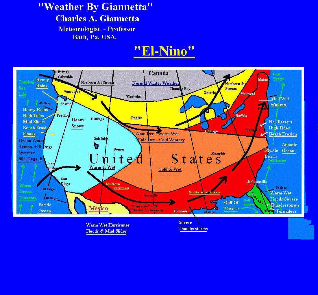
The Effects of El-Niño are strongest during the winter in the Northern Hemisphere, summer in the Southern Hemisphere. Winters are milder over portions of Western Canada, and the northern portions of the United States. Heavy rains and severe weather occur more frequently over the southern United States.
The northern polar jet stream associated with the polar front is a steering mechanism in the atmosphere. It forms a boundary between the cold dry air to the north and warm moist air to the south and is usually located over the central and southern United States during the winter months. During an El-Niño, the polar jet stream becomes situated further north along the U.S./Canadian border, in a somewhat west to east position. This position creates a blocking action of the cold air masses which are moving south from the interior of Canada and the Arctic regions, allowing warm moist air from the tropics to penetrate farther north than usual.
Another jet steam which is called the southern jet stream is usually located at 15-20 degrees north latitude. During El-Niño this jet shifts north over the southern United States to 30-35 degrees north latitude.
The southern jet brings with it warm moist air from the Pacific Ocean waters warmed by the effects of El-Niño, and moisture from the Gulf of Mexico. As the warm moist air enters the southwestern U.S., it is lifted over the western slopes of the Sierra Nevada mountains. Copious amounts of precipitation occur through the process of (Orographic Lifting).
The warm moist air continues eastward pulled along by the southern jet stream to over the southwestern U.S. As the warm moist air moves across the southern U.S., large amounts of rain occur. Heavy snow occurs over the Rocky Mts. at higher elevations such as Denver Co. which is 5,000 feet above sea level.
When conditions are favorable, heavy snows occur over the central and northeastern U.S. Many times the southern jet stream will turn northeast and bring abnormal warmer temperatures with heavy rains to the northeastern U.S. and Eastern Canada.
Weather conditions produced by El-Niño have good and bad effects. In the north-central and northeast U.S. and Canada one of the better effects would be the use of less fuel for heating our homes. Many ski resorts over the western U.S. experience early snowfalls which makes for early skiing.
Many countries in South America experience heavy rains producing major flood and land slides.
The weather which is usually warm and moist with monsoon conditions over Indonesia and portions of Australia becomes warm and dry. These dry conditions in turn aid forest fires. As these fires burn out of control, many homes are destroyed. Portions of southeast Africa are also hit with warm and dry conditions producing droughts and famine causing much suffering and many deaths to human and animal life.
Over the Hawaiian Islands the weather becomes warm and dry. Major droughts have occurred over the islands during an El-Niño.
El-Niño also has an effect on trading in the world stock markets. Rising or
falling prices of food, oil and other materials are affected. During an
El-Niño, millions of dollars in damage are caused by severe weather. Many
deaths are attributed to El-Niño through-out the world.
Typhoons which occur in the Pacific during an El-Niño are stronger and last longer. In the Atlantic hurricanes are frequently cut off from developing due to the southern jet stream. This jet stream situated at 30,000 to 40,000 feet above the surface of the earth, moves along at 50 to 300 mph generally from the west to east and shears off the tops of many tropical storms which could develop into hurricanes.
Through research and development we will gain a broader understanding of
the processes of El-Niño.
WE CAN'T STOP EL-NIÑO. BY BEING PREPARED, WE CAN CHANGE ITS OUTCOME.
© 1998 - 2013 Charles A. Giannetta