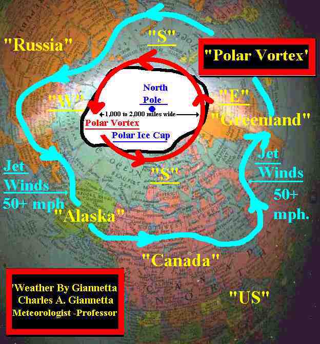
 "Polar Vortex"
"Polar Cyclone"
"Arctic Cyclone"
"Polar Vortex"
"Polar Cyclone"
"Arctic Cyclone"

A large scale "Upper Level Low Pressure" (CYCLONE)
at 15,000 to 20,000 feet. The air circulates
"Counter-Clock-Wise"


It is some 1,000 to 2,000 miles in diameter.
The system increases in strength during the winter months.

A "Upper Level Low" is cold air spinning
"Counter-Clock-Wise". The temperature may reach
-40 to -50 below zero F. This weather system produces
extremely cold and dry conditions in the form of an:
"ARCTIC AIR MASS"


When this Arctic Air Mass (POLAR VORTEX) moves south
over Canada and the United States or other regions such as
Russia and Europe can bring with it prolonged periods
of record breaking low temperatures.


The Arctic Air Mass (POLAR VORTEX) can move as far south as
the Gulf States and Florida.


When this Arctic Air Mass (Polar Vortex) becomes intrenched
over the United States and warm moist air (WARM AIR MASS)
moves north from the Tropical Regions, these two air
masses crash into each other and can produce record breaking
amounts of snowfalls and copious amounts of rainfall producing
miserable weather and living conditions such as hurricane type
windy conditions, blizzards, floods, flash floods, freezing rain
causing wide spread power outages from downed trees and power
lines to millions of people along with numerous deaths.


With the population growing and more and more construction
along the shores and throughout the United States, disasters
such as these will occur more frequently.


[THE BEST ONE CAN DO IS BE PREPARED. HAVE A PLAN OF ACTION]


This weather system (POLAR VORTEX) is nothing new and has
been around for eons. CG.

 "Weather By Giannetta"
 ....Back to index page.