 "Weather By Giannetta" "Weather By Giannetta" |
|---|
| "Weather By Giannetta" |
|---|
"Charles A. Giannetta"
|
|---|
 - "This page best viewed with "Microsoft Internet Explorer". Text Size "Smaller"
Picture 1024 X 768 - 17 or 21 inch Monitor
 - * * Gini & Charlie's Weather & Meteorology Glossary Page * * - - * * Gini & Charlie's Weather & Meteorology Glossary Page * * -
A |B |C |D |E |F |G |H |I |J |K |L |M |N |O |P |Q |R |S |T |U |V |W
|X |Y |Z
|
|---|
"C"
Calm:No wind.
"Change Of State"
1. Change Of State: The transfer of water from one form to another: Solid Ice: Liquid Water: Gas Vapor:
2. Condensation:    Change of water vapor to water. (Liquid).
3. Evaporation:     Change of water to water vapor: (Gas).
4. Freezing:        Change of water to solid: (Ice).
5. Melting:         Change of ice to liquid. (Water).
6. Sublimation:     Change of vapor to solid: (Ice)  Change of solid to vapor: (Gas).
"Climates"
Climates "A" Tropical & Warm. Avg. Yrly. Temp. 75 Degs. F. Parts of extreme Southern Florida, Miami: Mexico: Along the equator
"A"...Tropical......Humid...Hot & Wet
"C"...Subtropical...Rainy Mild Winter
"D"...Temperate.....4 Seasons
"E"...Borea.........Cold Winters
"F"...Fridgid.......Cold & Dry
Climate: The type of weather over and area or region based on many years of average weather information. Temperature, rainfall, snowfall, etc.
Cloud Droplets Cloud droplets are so small you could but more than a million in a teaspoon. At the center of each droplet of water
1. Clouds: At night mean warmer temperatures
2. Clouds: Altostratus: Light from MOON or Sun diffused.
3. Clouds: CB Cumulonimbus/Thunderclouds/Thunderstorms.
4. Clouds: CB Surface to 60,000+ feet.
5. Clouds: Cloudless sky at night are conditions favorable for dew to form.
6. Clouds: Contrails from Aircraft consists of ice crystals.
7. Clouds: Cumulus meaning Puffy.
8. Clouds: Cumulus fair weather.
9. Clouds: Dark Skys With Heavy Overcast.
10. Clouds: High 18,000 ft to 30.000+ ft. Cirrus/Cirrostratus.
11. Clouds: Lenticular: 30,000+ feet.
12. Clouds: Low surface to 6,500 Ft. Stratus/Stratocumulus/Cumulus.
13. Clouds: Mammatus/Thundercloud/CB/Thunderstorms.
14. Clouds: Middle 6,500 to 18,000 ft. Altostratus/Altocumulus.
15. Clouds: Penetrate Into The Startosphere.
16. Clouds: Produce "Green House Effect".
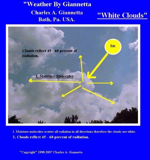
17. Clouds: Reflect 40 to 60 percent of radiation.
18. Clouds: Scarf/Anvil Top/Roll clouds with thunderstorms.
19. Clouds: Thundercloud/CB/Release Latent Heat.
20. Clouds: Vertical/Cumulus/Towering Cumulus.
21. Clouds: White in color produced by scattering light in all directions.
Clouds: Low:Clouds from the Earth's Surface to 6,500 feet. Stratus: Cumulus: Stratuscumulus: Scud:
Calorie:The amount of heat required to raise 1 gram of water 1 Deg. C. A gram is about the size of a small paper clip.
Calm: No wind: No movement of air:
Carbon Dioxide: Colorless, odorless gas. CO2.
CAT: "Clear Air Turbulence" turbulence that occurs in clear air with no clouds..
Carbon Monoxide: CO: Is oderless and colorless and can kill you.
Carotenoids: Yellow & Orange colors in leaves.
CAVU: Clear. Visibility 10+ miles.
CB: Cumulonimbus cloud.
CCL: Convective Condensation Level: The level at which condensation forms. (Clouds)
Ceiling: Height above the ground of the lowest based layer of clouds reported as broken or overcast.
Ceiling Balloon:A small baloon 10, 30, 100 gram filled with helium sent aloft to determine the cloud ceiling in feet above the ground.
Ceiling Light: A weather instrument used to measure the height of clouds above the ground.
Ceiling Unlimited: Clear skies or scattered cloud conditions.
Ceilometer: A weather instrument which is used to determine the height of clouds about the ground.
Celsius Temperature Scale: Named after "Andres Celsius" Celsius symbol is "C". O Degrees is freezing and 100 degrees is the
boiling point of water.
Centrifugal Force:Centrifugal Force: Greatest at the equator.
Centripetal Force:Inward movement. Center seeking.
Certified Weather Observer: Someone certified and approved by a designated federal agency to take and record weather observations.
CFC: Chloro-Fluro-Carbons: Produced by automobils and are air pollutants.
Chinook Wind:Chinook Wind: An Indian name for "Snow Eater" Warm & dry winds which flow downward (Downslope) at
speed of upwards of 100 mph capable of producing much damage to life and property. (Foehn Wind)
Circulation: A continuous movement of air.
Cirroform: High clouds of ice.
Cirrostratus: Middle clouds at 6,500 feet to 18,000 feet.
Cirrus Cloud:Couds which are between 18,000 & 30,000 feet. Are wispy and consist of ice crystals.
Civil Twilight: When the sun is no more than 6 Degs. below the horizon before sunrise and after sunset.
Climates "B" Dry Climates: Arid Deserts: North Africa:
Climates "C" Subtropical: Rainy, mild winters. Avg yearly temperatures 60 degs. F. Southern United States.
Climates "D" Temperate: Neither very hot or cold having the 4 seasons. Avg. yearly temperature 45 degs. F. Central & Northern US.
Climates "E" Boreal: Cold winters mild summers. Avg. temperatures 45 degs. F. Canada.
Climates "F" Polar: Cold & Day: Frigid temperatures. Polar Regions.
Climates "G" Highland Climates: China: manchuria:
Clear Air Turbulence: "CAT": Turbulence that occurs in clear air with no clouds..
Clear Ice: Clear and glossay and identical as glaze which forms on trees etc. It can be smooth or rough.
Clear Sky Condition: When the sky is cloudless or is less than .1 cover.

Climate Controls: Sourch Regions: Mountains: Valley: Oceans: Great Lakes: Land: Latitude: Longitude:
Climatology: The study of Climate.
Clouds:Any cloud from delicate wispy ice crystals six miles above the earth to a pea-soup London Fog, is a portion of air
Cloud Burst: A sudden downpour of heavy rain.
that has condensed into visibly moisture. Cooling of air to its dew point is the main reason for most cloud formation.
The chief cause of cooling lies in some process which causes air to rise or to move upwards.

or ice is even a smaller speck of: Dust: Dirt: Smoke: Salt: Soot: called "Nuclei".
Cloud Nuclei: Dust: Dirt: Smoke: Salt: Soot:
Clouds: Middle:Clouds from 6,500 feet to 18,000 feet. Altostratus: Altocumulus:
Clouds: High:Clouds from the 18,000 feet to 30,000+ feet. Cirrus: Cirrostartus: Cirrocumulus:
Clouds: Verticle:Cumulonimbus: Thundercloud: Surface to 60,000+ feet. (CB)
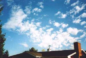
Clouds: Low:Clouds from the Earth's Surface to 6,500 feet. Stratus: Cumulus: Stratuscumulus: Scud:
Pictures of "Low Clouds"
Clouds: Middle:Clouds from 6,500 feet to 18,000 feet. Altostratus: Altocumulus:
 -
-  -
- 
Pictures of "Middle Clouds"
 -
-  -
- 
Picture Altocumulus Clouds.
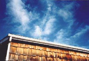
Clouds: High:Clouds from the 18,000 feet to 30,000+ feet. Cirrus: Cirrostartus: Cirrocumulus:
 -
-  -
- 
Picture Cirrus Clouds.
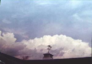
Clouds: Verticle:Cumulonimbus: Thundercloud: Surface to 60,000+ feet. (CB)
 -
-  -
-  Picture Cumulus & Cumulonimbus Clouds.
|
|---|

Coalescence Process: The process by which water droplts falling collied (Coalescence)
and grow larger.
Col: A neutral area between two high pressure systems or two low pressure systems.
Cold Air: Moves towards warm air.
Cold Air: Is heavy and sinks. Will lift up warmer air.
Cold Air Advection: The horizontal transfer of cold air to warm air.
Cold Air Occlusion: When cold air overtakes and replaces warm air.
Cold Air Occlusion Symbol: 
Cold Core Weather Systems: Weather systems with the lowest temperatures at or near the center and gain their energy from the temperature variations
within the atmosphere.
Cold Front: When cold air moves to replace warm air.
Cold Front Symbol: 
Cold Sector:
 -
- 
Condense: To change from a vapor to a liquid.
Contrails:Condensation fromed by the exhaust of an aircraft.
Cyclonic Conditions: Expansional Cooling.
"Example"   Max  80
            Min  60
           ---------
           Mean  70

Surtract 65 Degs which is the base temperature from the mean temperature of 70.  We now have 5 Cooling Degree Days for that day.
Coriolis Effect: In the Northern Hemisphere the wind is turned to the right due to the Earth's rotation. This is called the: Coriolis Effect.
Corona: A colored glow around the sun.
"A"
A: Arctic Air Mass.
"B"
BCKG: Backing.
"C"
CB: Cumulonimbus Cloud. Thunderstorm.
"D"
DA: Density Altitude.
"E"
EMBDD: Embedded.
"F"
FC: Funnel Cloud.
"G"
GF: Groundfog.
"H"
H: Haze.
"I"
ICG: Icing.
"K"
KDEP: Smoke Layer.
"L"
LFC: Level Of Free Convection.
Condensation Level: The height at which rising air becomes saturated.
Condensation Level: The height at which rising air becomes saturated.
Condensation Nuclei: Microscopic particles of dust, dirt, CO2, Salt, Etc Smoke which water vapor needs for condensation.

 -
- 
Pictures of "Contrails" over our house.
CP: Designated letters for a Continental Polar Air Mass:
Continental Polar Air Mass: Continental Polar Air Mass: "CP": An air mass which forms over Canada and is cold and dry.
CT: Designated letters for a Continental Tropical Air Mass:
Continental Tropical Air Mass: Continental Tropical Air Mass: "CT": Warm & Dry air mass that forms over the southwestern deserts of the United States.
Contour: A line connecting all points of the same elevation.
Contraction: Shortened word or acronyms used inplace of a word or phrase. EX. "RADAR"
Convection: Rising air currents.
Convergence:In the atmosphere when air converges it comes togethere and rises, moves counter-clock-wise, center seeking, creating "Low Pressure: "Centripetal Force".

Cooling Degree Days: Cooling Degree days are based on a mean temperature of 65 Degrees.
To arrive at the mean temperature add the max and min temperature for the day, divide by 2 to get the mean or average for that day.
If the mean temperature is above 65 degrees than we have "Cooling Degree Days" for that day.
Named after the French Scientiest: "Gustav Coriolis, 1835.

Cross Section Of The Atmosphere : Looking at the atmosphere from a vertical point.
CS: Cirrostratus clouds.
Cumulus Cloud:Puffy white fair weather clouds that result from rising air currents (Thermals).
Cut Off Low or High:Low or High pressure systems which are cutoff from the main west to east flow.
Cyclogenesis: The birth of a cyclone.
Cyclolysis: The ending of a cyclone.
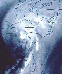
Cyclone:A low pressure system: Also, a name given for a hurricane in the Pacific.
Cyclonic: Low Pressure: Counter-Clock-Wise Air Flow: Rising Air:
Contraction: Shortened word or acronyms used inplace of a word or phrase. EX. "RADAR"
AC: Altocumulus Clouds.
ACLD: Above Clouds.
ACSL: Standing Lenticular altocumulus.
ACYC: Anti-Cyclonic.
AFDK: After Dark.
AFW: Air Force Weather
AGL: Above Ground Level.
ALQUADS: All Quads.
AS: Altostratus Clouds.
BFDK: Before Dark.
BINOVC: Breaks In The Overcast.
BKN: Broken.
BLZD: Blizzard.
BOVC: Base Of Overcast.
CBMAM: Cumulonimbus Mamma. Thunderstorm Cloud.
CC Cirrocululus Clouds.
CFP: Cold Frontal Passage.
CI: Cirrus Clouds.
CONUS: Continental United States.
CP: Continental Polar Air Mass..
CS: Cirrostratus Clouds.
CTNUS: Continental Tropical Air Mass.
CU: Cumulus Clouds.
CUFRA: Cumulus Fractus Clouds.
CYC: Cyclone.
DFUS: Defuse.
DNSLP: Downslope.
DP: Deep.
DS: Dust Storm.
DU: Dust.
DWNDFTS: Downdrafts.
DZ: Drizzle.
FG: Fog.
FIH: Flight Information Handbook.
FNTGNS: Frontogenesis. Front Froming.
FFNTLYS: Frontolysis. Front Dissipating.
FROPA: Frontal Passage.
FZ: Freezing.
HLSTO: Hailstones.
HLYR: Haze Layer Aloft.
ICGIC: Iceing In Clouds.
ICGICIP: Icing In Clouds & Precipitation.
ICGP: Icing IN Precipitation.
INTMT: Intermittent.
INVER: Inversion.
IPV: Improv.
ISOLD: Insolated.
KLYR: Smoke Layer Aloft.
KOCTY: Smoke Over City.
LLWS: Low Level Wind Shear.
LLGT, LTNG: Lightning.
LGTCC: Lightning Cloud To Cloud.