 "Weather By Giannetta" "Weather By Giannetta" |
|---|
| "Weather By Giannetta" |
|---|
"Charles A. Giannetta"
|
|---|
 - "This page best viewed with "Microsoft Internet Explorer". Text Size "Smaller"
Picture 1024 X 768 - 17 or 21 inch Monitor
 - * * Gini & Charlie's Weather & Meteorology Glossary Page * * - - * * Gini & Charlie's Weather & Meteorology Glossary Page * * -
A |B |C |D |E |F |G |H |I |J |K |L |M |N |O |P |Q |R |S |T |U |V |W
|X |Y |Z
|
|---|
"S"
S- Designated letter for light.
Santa Ana Winds: Are downsloping warm dry winds, (Fohen) which occur when there is a large High Pressure System located
over the Rocky Mountains. With the clock-wise wind circulation produce by the High Pressure, these winds move down the
western slopes of the Rockies and desert areas of the Southwest and move over Southern California producing very warm
and dry conditions for this region.
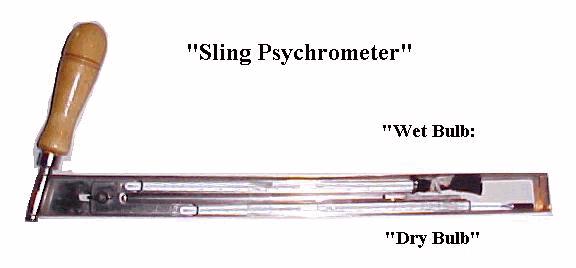
Saturation Vapor Pressure:The total amount of moisture the air can hold at a given temperature. Also expressed as: "Saturation Mixing Ratio".
Same as: Saturation Mixing Ratio:
"Example" Vapor Pressure = 10
----- .50 X 100 = Relative Humidity = 50%
Saturation Vapor Pressure = 20
SAWARS: Supplemental Aviation Weather Reporting Station.
Secondary Air Pollutants: Acid Rain: Smog: Surlur Oxide: Nitorgen Oxide: Carbon Monoxide:
"Seconds In Time"
Femtosecond: One millionth of a nanosecond.
Sensible Heat:The Transfer of heart from one place to another via: Radiation: Conduction: Convection: Condensation:
Severe Blizzard Warning:Winds stronger than 45 mph. Visibility near zero. Temperature below 10 degs. F. Dangerously low wind chill temperatures.
Severe Thunderstorm Watch: Severe thunderstormas are possible.
Severe Thunderstorm Warning: Severe thunderstorms are occurring.
Severe Thunderstorm Warning: 1 Hour 50 mph winds 3/4 in hail.
Sheet Lightning: Lightning which occurs inside the clouds.
Shower: Sudden bursts of precipitation (rain or snow, etc) that change rapidy in intensity & starts and stops.
Showers: Sudden bursts of precipitation (rain or snow, etc) that change rapidy in intensity & starts and stops.
Showery: Sudden bursts of precipitation (rain or snow, etc) that change rapidy in intensity & starts and stops.
Sigmet: Acronym for: Significant Meteorological Information: Inflight weather advisory forecast for hazardous weather conditions for all aircraft.
"Sky Condition"
1. Clear Or Sunny: 0/10 to 1/10 cloud cover.
Sky: "Why The Sky Is Blue":
Sky Cover: The amount of sky that is hidden by clouds or obsurcations.
Slant Visibility: The distance a pilot can see the landing aids (Lights) on the runway.
Sleet: Frozen Rain.
Smog: A mixture of smoke and fog.
Smoke: Small particles produced by combustion suspended in the atmosphere.
Snow: Ice crystals which have six points.
Snow Cover Chart.
MORE TEXT TO COME"
"Snow Intensities"
1. Snow: Light:....Visibility greater than 1/2 mile.
2. Snow: Moderate: Visibility greater than 1/4 mile but 1/2 mile or less.
3. Snow: Heavy:....Visibility 1/4 mile or less.
"SNOW"
1.  Snow At Christmas. Usually not any for this (Lehigh Valley, Pa.) area.
2.  Snow Board. For measuing new fallen snow. Away from buildings and trees.
3.  Snowburst. Extreme lake effect snow blocking roads.
4.  Lake Effect snow for Western New York. ART/BUF/ROC/SYR/BGM
5.  Lake Effect snow/storms.
6.  Lake Effect storms over the Great Lakes.
7.  Snow Fence. Used to deflect snow.
8.  Snow: Fetch. To pick up moisture.
9.  Snow Grains. Very small, white, opaque grains of ice much like drizzle but are frozen. Dimeter less than 1 mm.
10. Snow: Measueing. Location. Ruler. Measuring stick.
11. Snow Pellets. Soft conicial or sperical white particles of ice with diameters of 1 to 5 mm.
12. Snow Squalls.
13. Snow: Symbols.
14. Snow. Trace. Less than a 1/2 inch (.5) of snow.
15. Snow: Water equivilant. Usually 10 inches of snow to 1 inch of rain. Can be as
          low as 7 inches to as high as 30 inches of snow.
16. Snow: Contains ice crystals that are usually six sided.
Snow Board: A board for measuring snowfall.
Snow Core Sample: A core sample of the snow cover to measure how much liquid precipitaion is within the core.
Solar Angle: High:"High Solar Angle" when the Sun is directly overhead.
Solar Angle: Low:"Low Solar Angle" when the Sun is low on the horizon.
Solar Wind: Is produced by charged ion particles escaping from the Sun.
Solar Wind: The solar wind moves on average about 400 kilometers per sec/ 250 mps. It takes 2-3 days for the solar particles to reach the Earth.
Source Regions: Regions where an air mass forms. (Example: The Arctic).
Stability: Absolute Instability: Adiabatic lapse rate greater than 5 degs. F.,3.0 degs. C. per 1,000 feet.
Stability: Absolute Stability Isothermal: Temperature remaing the same from surface to some point aloft.
Stability: Absolute Stability Inversion: Temperature warmimg as air ascends.
Stability: Absolute Stability: Adiabatice lapse remaing at 5 degrees F., 3.0 degs. C. per 1,000 feet.
Stability: Conditional Stability: Adiabatic temperature between 5 Deg. F., 3.0 Degs. C. per 1,000 feet.
Stability: Dry Adiabatic Lapse Rate: 5 Degs. F., 3 Degs. C. per 1,000 feet.
Stability: Moist Adiabatic Lapse Rate: 3 Degs. F., 1.5 Degs. C. per 1,000 feet.
Stability Index: The stability index is used in determimg the stability of the atmosphere. Is is a good guide as to the stability of the atmosphere:
It is a good indicator as to whether air will ascend or not. A negative stability index indicates air will rise . A positive stability index will
indicate the air will rise slowly or not at all. If the rising air is warmer than the surrounding air it will continue to rise, this will indicate a
negative stability index. The more unstable the parcel of air the more likely it will continue to rise with the possibility of severe weather.
The more stable the air is indicates that the air will rise slowly or not at all.
Sun: Sun: My Article.
Sunspot:
S Designated letter for moderate snow.
S+ Designated letter for heavy snow.
Saint Elmo's Fire: A weather phenomenon: A liminous glow of electricity produced on objects of a ship or aircraft tall structures
during a thunderstorm. It is not lightning. It is named after St. Erasmus the patron Saint of Sailors.
Saffir - Simpson Hurricane Intensity Scale is know after its designers. H. S. Saffer, a consulting engineer, and R. H. Simpson,
former director of the National Hurricane Center. A hurricane intensity scale based on the Hurricanes central Pressure:
Wind Speed: and the damage the storm has or may cause.
Sandstorm: Particles of sand carried aloft by the wind.

Air (Wind) moving from the sea to over land. Begins several hours after sunrise. Reaches max by mid-afternoon and is stronger than a Land Breeze.
Scarf Cloud: A cloud which forms around and near the top of a thunderstorm and resembles a scraf.
Scattered Sky Condition: When the sky cover is 0.1 through 0.5.
Sea Breeze:


Microsecond: One millionth of a second.
Millisecond: One thousandth of a second.
Nanosecond: One billionth of a second.
Picosecond: One trillionth of a second.
Sir Isaac Newton:Born Jan 4, 1643. Died March 31, 1727. An English physicist/mathematician/astronomer.
2. Fair: Less than 4/10 cloud cover and no weather.
3. Partly Cloudy or Partly Sunny: 3/10 to 6/10 cloud cover.
4. Mostly Cloudy: 7/10 to 8/10 cloud cover.
5. Cloudy Or Overcast: 9/10 to 10/10 cloud cover.
Sky: "Why The Sky Is "ORANGE" "YELLOW" "BROWN":
Sky: "Why The Sky Is RED":

 -
- 


Solar Halo: A ring around the Sun produced by cirrostratus clouds which consist of ice crystals

Specific Heat Of Water:Specific Heat Of Water is 1.0: Water takes longer to heat and longer to cool than any other substance.
Specific Humidity:The ration of the mass of water vapor (in grams) to the mass (in kilograms) of air containing the water vapor, expressed as grams of water vapor per kilogram of humid air.
The combined mass of dry air plus water vapor.
Speed of Light:186,000 miles per second.
Speed of Sound:
Squal Line: A area ahead of a cold front with very active and sometimes violent weather.

Squals: Sudden gusts of wind that increase 15 to 20 knots thats last for a short duration many times with heavy rain or snow.

Standard Height of the 925 mb Chart: - - - 2,500 Feet. 925mb = 761 Meters. On the WX Map plotted as 761 meters.
Standard Height of the 850 mb Chart:
Standard Barometric Pressure: Standard Barometric Pressure at sea level is: 1013.2 mb. 29.92 inches of mecury. 14.7 lbs. per sq. inch. at a
standard temperature of 59 degs. F.
Station Elevation: The height of the station above sea level.
Stationary Front Symbol: 
Station Model: How a surface weather map is plotted.
Station Pressure: Atmospheric pressure at the station height.
Stepped Leader: Streams of electrons which move from a thunderstorm cloud towards the ground in steps of about
300 feet and produce an ionized path. When the Stepped Leader comes within about 300 feet of the ground it is
met by a charge from the ground to complete the path.
Stratosphere: Varies with height from over 60,000 feet along the equator to 40- 45,000 feet above the poles.
Storm Surge: An rise of coastal water as a result of winds and storms at sea.
Sublimation: When a solid goes to the vapor stage without entering the liquid stage.
Summer Soltice: Occures on or about June 21st.
Surface Visibility: Surface visibility determined at a defined location.


SW- Designated letter for light snow showers.
SW Designated letter for moderate snow showers.
SW+ Designated letter for heavy snow showers.
Synoptic Weather Chart: A weather map depiciting the current weather conditions.
Synoptic Weather Systems: Hurricanes: Typhoons: Cyclones:
© 1998 - 2013 Charles A. Giannetta
| Weather Glossary...WEATHER BY GIANNETTA,Giannetta,Charles,WA3RSQ,EL-NINO,Weather,Magazines,Meteorology,Hurricanes, Tornadoes,Floods,Clouds,Radar,Forecasting,Thunderstorms,Lightning,Atmosphere,69,Grand,Prix, WXDATA,Bath,Pa,USA,CD ROM,Weather,Disk,Meteorology,Graphics,Research,weatherbygiannetta.com |
|---|